
GPS Map Camera: Photo Maps
Map Camera Lite: Photo Maps, Weather, unaddressed place detection & live photo!
Frisco Apps Inc.
GPS Map Camera: Photo Maps is developed and provided by Frisco Apps Inc.. LDPlayer offers the download service only.
Version1.1.5
Rating4
Categorygpsmapcamera.gpscamera.time
Package name5+
Downloads1.1.5
GPS Map Camera: Photo Maps Description
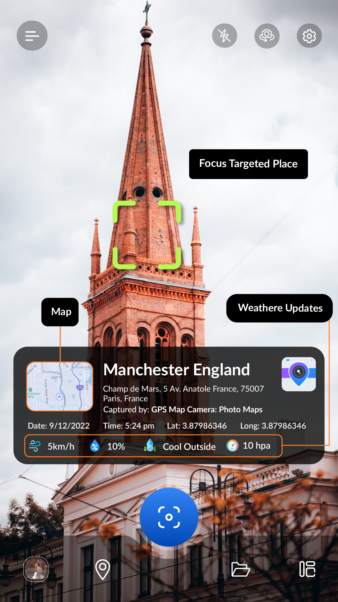
GPS Map Camera & Photo Maps is a mobile application that combines the power of GPS location live tracker and location changer with the convenience of a Camera App Lite and Live Photo. This GPS application is designed to make it easy for users to capture live photos and geolocation while also keeping track of the exact location where the media captured photos. The GPS Map Camera lite app comes with a lot of features, including Photo Maps, Weather, unaddressed place detection & live photo, GPS MAP Camera Lite-Time Stamp, Datetime, Latitude, Longitude, Weather, Magnetic field, Compass, and my altitude to Your App Camera Photos and more.
One of the key features of the GPS Map Camera App is its ability to provide users with precise latitude and longitude data and Geotag Photos & Add GPS Location Application. This feature allows users to pinpoint the exact location where a live photo or live location photo was captured, which can be incredibly useful for a variety of applications. For example, a photographer might use this feature to keep track of the locations where they have taken photos for their portfolio.
Another powerful feature of GPS Map Camera lite is its GPS Location Tracker. This feature allows users to track their live location in real-time, which can be useful for an application, such as hiking, running, or cycling. By using this feature, users can keep track of their progress and ensure that they are on the right track.
Interesting Feature
👉 GPS MAP Camera Lite
👉 Live Location and Live Photo Tracker
👉 Find photo location stamp
👉 Geotagged Camera & gps location tracker app
👉 Put Longitude, Latitude, Address, Date-Time, Location stamp to Photos
👉 Get Live Location image stamp with simple camera GPS
The Map Camera lite feature of GPS Map Camera is another powerful tool that users can take advantage of. With this feature, users can add a map stamp-Time Stamp and geotag to their Geotag Photos & Add GPS Location. This can be incredibly useful for of mobile applications, such as travel and live location photo blogging or documenting a hiking trip.
In addition to these features, GPS Map Camera lite also comes with a variety of other tools and features that users can take advantage of. For example,
the app includes a GPS Track Locator, which can be used to find nearby points of interest or navigate to a specific location gps location tracker. The app also includes a variety of weather tools, such as live weather updates and forecasts, which can be useful for planning outdoor activities.
Overall, GPS Map Camera lite is a powerful mobile application with the power of GPS live location tracking with the convenience of a Camera lite app. With its precise latitude and longitude data, real-time GPS tracking, and map camera features, this app is an incredibly useful tool for anyone who wants to document their travels or keep track of their live Location Tracker while on the go.
Open up


Download GPS Map Camera: Photo Maps APK for Android
1. Click "download GPS Map Camera: Photo Maps APK for Android"
2. Install GPS Map Camera: Photo Maps
3. Launch and enjoy GPS Map Camera: Photo Maps
Get from Play Store
1. Click "Get from Play Store
2. Download GPS Map Camera: Photo Maps from the Play Store
3. Launch and enjoy GPS Map Camera: Photo Maps
Is GPS Map Camera: Photo Maps safe for my device?
Open up
Yes, GPS Map Camera: Photo Maps follows the Google Play content guidelines to ensure safe use on your Android device.
What is an XAPK file, and what should I do if the GPS Map Camera: Photo Maps I downloaded is an XAPK file?
Open up
A file with .xapk extension is a compressed package file. It is a container file format that incorporates APK and additional associated files required for the installation.
The XAPK format was introduced to package the APK file and OBB file together for a seamless delivery and installation process.
XAPK format can help reduce the package size of application.
On mobile phones, users need to install the XAPK installer first, and then install XAPK files through that installer. You can find the installer here:https://apkcombo.com/how-to-install/. But on PC client, you just need to put the file on LDPlayer.
Can I play GPS Map Camera: Photo Maps on my computer?
Open up
Yes, you can play GPS Map Camera: Photo Maps on your computer by installing LDPlayer, an Android emulator. After installing LDPlayer, simply drag and drop the downloaded APK file into the emulator to start playing GPS Map Camera: Photo Maps on PC. Alternatively, you can open the emulator, search for the game or app you want to play, and install it from there.
Search Recommendation