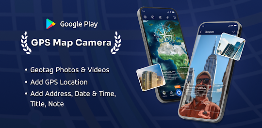
GPS Map Camera Description
Unlock a world of precision photography with GPS Map Camera - your ultimate companion for location-based image capture. Seamlessly blend the power of GPS technology with your camera, geotagging each photo to create a visual journey. 📸
Exciting Features:
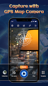
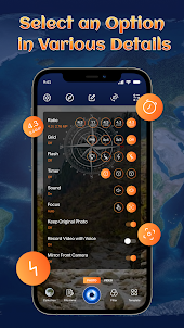
- Leverage a digital camera equipped with a grid, ratio control, front & selfie camera options, flash, focus settings, mirror mode, timer, and capture sound support.
- Seamlessly toggle between automatic and manual map data settings to tailor your location preferences.
- Explore the Classic Template, which effortlessly incorporates automatically fetched geological map stamp details for a timeless touch.
Advance Template Features
Customize Map Style:
Tailor your map experience by seamlessly switching between normal, satellite, terrain, and hybrid options.
Location Tagging:
Stamp your selected manual or automatic current location onto your images for a personalized touch.
Geo-Coordinates Embedding:
Enhance your geolocation photo stamp by setting precise GPS coordinates with latitude and longitude.
Timestamp Options:
Imprint date and time onto your photos in various formats, accompanied by additional geographical map data.
Branded Identity:
Elevate your images with a touch of professionalism by uploading and embedding your own brand logo.
Personalized Notes:
Infuse meaning into your memories by adding relatable and personalized notes to your captured moments.
Hashtag Integration:
Boost your image visibility by effortlessly incorporating relevant hashtags related to your stunning visuals.
Live Weather Data:
Stay informed about the weather conditions by measuring temperature units and embedding live, accurate weather data onto your photos.
Auto Compass Directions:
Enhance your geotagged images with auto digital compass directions for added navigational context.
Magnetic Field Details:
Gain insights into your surroundings with auto-detection and display of magnetic field details on your photos.
Wind Speed Measurement:
Capture the dynamic aspect of your environment by measuring and showcasing the wind speed on your images.
Automatic Humidity Measurement:
Elevate the atmospheric details in your photos with automatic humidity measurements for a comprehensive view.
Pressure Gauge:
Add depth to your location data by measuring and displaying the atmospheric pressure of the captured place.
Altitude Calculation:
Enable automatic altitude calculation, providing valuable elevation information to your geotagged images.
Precision Accuracy:
Ensure the accuracy of your location data by embedding auto-calculated accuracy details directly onto your images
Most Efficient Application For The Following Groups of People:
➩ Business & Infrastructure: Individuals in fields related to real estate, infrastructure, and architecture can effortlessly apply GPS Map Location stamps to their site photos. 🏢🌐
➩ Celebration Enthusiasts: People hosting destination festivities like weddings, birthdays, festivals, and anniversaries can add a personalized touch with GPS Map Camera. 🎉📸
➩ Travel Enthusiasts: Travelers and explorers can effectively use the Geo-tagging camera to document their journeys and adventures. ✈️🗺️
➩ Corporate Travelers: Individuals attending outstation meetings, gatherings, conclaves, meetups, and events can efficiently capture and share their experiences for professional purposes. 🤝🏛️
➩ Content Creators: Travel, food, style, and art bloggers can enhance their narratives by including GPS locations through GPS Map Camera. 🌍📷
➩ Location-Based Businesses: Spot-oriented businesses, where you need to send pictures with live location details to clients, can streamline their communication with the GPS Map Camera. 📍📲
Unlock the potential of these captivating features by downloading GPS Map Camera: Geotag Photos & Add GPS Location Application on your mobile device.
Share your best experiences with us through Ratings & Reviews – we'd love to hear from you!
Exciting Features:
- Leverage a digital camera equipped with a grid, ratio control, front & selfie camera options, flash, focus settings, mirror mode, timer, and capture sound support.
- Seamlessly toggle between automatic and manual map data settings to tailor your location preferences.
- Explore the Classic Template, which effortlessly incorporates automatically fetched geological map stamp details for a timeless touch.
Advance Template Features
Customize Map Style:
Tailor your map experience by seamlessly switching between normal, satellite, terrain, and hybrid options.
Location Tagging:
Stamp your selected manual or automatic current location onto your images for a personalized touch.
Geo-Coordinates Embedding:
Enhance your geolocation photo stamp by setting precise GPS coordinates with latitude and longitude.
Timestamp Options:
Imprint date and time onto your photos in various formats, accompanied by additional geographical map data.
Branded Identity:
Elevate your images with a touch of professionalism by uploading and embedding your own brand logo.
Personalized Notes:
Infuse meaning into your memories by adding relatable and personalized notes to your captured moments.
Hashtag Integration:
Boost your image visibility by effortlessly incorporating relevant hashtags related to your stunning visuals.
Live Weather Data:
Stay informed about the weather conditions by measuring temperature units and embedding live, accurate weather data onto your photos.
Auto Compass Directions:
Enhance your geotagged images with auto digital compass directions for added navigational context.
Magnetic Field Details:
Gain insights into your surroundings with auto-detection and display of magnetic field details on your photos.
Wind Speed Measurement:
Capture the dynamic aspect of your environment by measuring and showcasing the wind speed on your images.
Automatic Humidity Measurement:
Elevate the atmospheric details in your photos with automatic humidity measurements for a comprehensive view.
Pressure Gauge:
Add depth to your location data by measuring and displaying the atmospheric pressure of the captured place.
Altitude Calculation:
Enable automatic altitude calculation, providing valuable elevation information to your geotagged images.
Precision Accuracy:
Ensure the accuracy of your location data by embedding auto-calculated accuracy details directly onto your images
Most Efficient Application For The Following Groups of People:
➩ Business & Infrastructure: Individuals in fields related to real estate, infrastructure, and architecture can effortlessly apply GPS Map Location stamps to their site photos. 🏢🌐
➩ Celebration Enthusiasts: People hosting destination festivities like weddings, birthdays, festivals, and anniversaries can add a personalized touch with GPS Map Camera. 🎉📸
➩ Travel Enthusiasts: Travelers and explorers can effectively use the Geo-tagging camera to document their journeys and adventures. ✈️🗺️
➩ Corporate Travelers: Individuals attending outstation meetings, gatherings, conclaves, meetups, and events can efficiently capture and share their experiences for professional purposes. 🤝🏛️
➩ Content Creators: Travel, food, style, and art bloggers can enhance their narratives by including GPS locations through GPS Map Camera. 🌍📷
➩ Location-Based Businesses: Spot-oriented businesses, where you need to send pictures with live location details to clients, can streamline their communication with the GPS Map Camera. 📍📲
Unlock the potential of these captivating features by downloading GPS Map Camera: Geotag Photos & Add GPS Location Application on your mobile device.
Share your best experiences with us through Ratings & Reviews – we'd love to hear from you!
Open up